
PLEASANT TOWNSHIP
Harrisburg – Darbydale – Georgesville – Pleasant Corners – Miller’s Station
Pleasant Township was organized in 1807 and at the time it was five times larger than it is today. In 1815, a portion of its land mass was taken to create Jackson Township; additional Pleasant Township land was taken in 1819 to help create Prairie Township.
Brothers Thomas and Elijah Chenoweth of Maryland were the first settlers in what would become Pleasant Township. They had moved from their home in Maryland to Pike County, Ohio. Planning a move north, the brothers purchased 200 acres in what would become Pleasant Township in 1799 from Lucas Sullivant who was living at Franklinton.
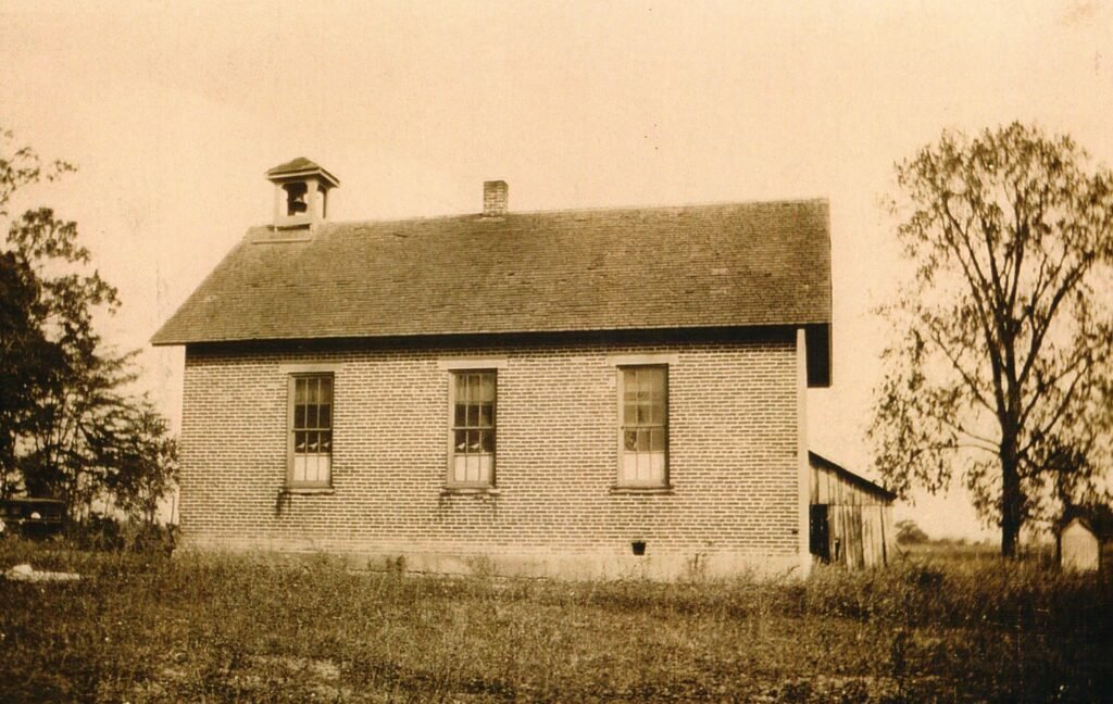
This is a picture of the Story School once located in Pleasant Township. Pleasant View Middle School, 7255 Kropp Road, now stands on that site.
John and Margaret Gibson Biggart were also early settlers arriving around 1800. Biggart is credited as building the first brick home in Pleasant Township sometime before 1812. Other early settlers included Thomas Roberts, John Bigger, James Garliner, Samuel Dyer, Samuel Kerr and John Turner. Early township trustees included Henry Miller, Joseph Chenoweth, O. T. Curry, L. W. Seifert and George W. Helmick.
Most businesses in Pleasant Township were linked to farming; other occupations included blacksmith, carpenter, broom maker and lumber dealer. There were also several grocery stores in the township. The township would eventually have 13 schools.
In 1805, Samuel Dyer built a mill at the forks of Little Darby and Big Darby Creeks. The mill was located between Georgesville and New Georgesville. It became the center of community life for the early pioneer, according to research by Bill Howison. Early settlers traveled from Union and Delaware Counties to Dyer’s Mill, the first mill built north of Chillicothe. A common sight along the Darby was a settler with knotted sacks of grain across the back of his horse and a rifle across his saddle. Others, such as Andrew Noteman, brought grain down the Darby by dugout canoe. Howison recorded those historical comments in his Wilderness Village Along the Darby published in Reflections, a Southwest Franklin County Historical Society book. Little Darby Creek was once known as Treacle [some documents have it as Treakles] Creek, Howison wrote.
By 1872, there were two grist mills in the township. One was operated by Thomas Chenoweth, the eldest son of Elijah and Rachel Chenoweth. He had created a large grain and flour business on the north bank of Big Darby Creek just north of where Opossum Road [early spelling] and Harrisburgh-Georgesville roads intersected.
“The prairie or open land was believed to be worthless for agricultural purposes and was the last to be entered,” according to Bill Howison. “It was low and wet, and the malaria it engendered caused it to be shunned. This land was valued at 50 cents to $2 per acre, while wild land commanded $3 an acre. The first settlers thought this land would always be available for pasture.”
There are no records showing who were the first elected officials of the township but the following were justices of the peace during the first years: William Brown, William Badger, Woolley Conrad, William C. Duff, William Seeds, Jacob B. Deimer, John Gantz, Joshua Glanville, Robert Seeds, Isaac Miller, H. S. Mitchell, Isaac White, E. C. Brett, Henry Andrews, A. C. Borror, G. W. Hoover, W. P. White, J. B. Mitchell, H. C. Darnell, J. White Sr., T. J. Adams, and John S. Borror. These officers served up to and including the year of 1880.
Pleasant Township’s population in 1840 was over 800. By 1908 the population had grown to 2,355 and by 2010 the population was 6,671 people. Many of the township communities were known for their annual Fish Fries that helped raise money to support their volunteer fire departments. People traveled from throughout Ohio to attend these weekend festivals that always included grand parades and family reunions.
Harrisburgh – Harrisburg
In 1799, the Elijah and Rachel Chenoweth family left Pike County, Ohio with their two children and settled in what is now the Pleasant Township area of Franklin County. Elijah was 37 years old when he moved his young family to Central Ohio.
Chenoweth’s land was originally part of the Virginia Military Grant made to Nicholas Massenburgh in 1796 for his service in the American Revolution. Lucas Sullivant, the man who settled and created the town of Franklinton, then purchased the land. Chenoweth and his brother, Thomas, purchased 200 acres from Sullivant in 1799 at Franklinton.

Chenoweth’s log home in Pee Pee Township, Pike County, Ohio. A Chenoweth family member founded Harrisburgh.
Drawing provided by Pike County Historian Jim Henry
After living several years in their cabin, Elijah built a larger log cabin about a half mile north of the village. The house was located in a low area and was built about 1806. It eventually evolved into a 14-room home. Elijah and Rachel’s children included Thomas and John, both born in Pike County; Joseph, Rachel, Cassandra, Elizabeth and Elijah, all born in Central Ohio.
When the Chenoweth family arrived in the area, the settlement was known as Darby Cross Roads. It would be years before Harrisburgh came into existence. A small school was located in the area in 1811 and around 1817 a new log school was built in the southwest corner of the village. It’s believed a frame school was built sometime after the village was created.
Some people in the area referred to the settlement as Mudsock. Harrisburg was indeed a “mudsock” settlement because it was common for “locals” to sneak out and get muddy socks heading to taverns in the village, according to a Facebook post by Mike Hummel. He added Harrisburg was a lively stagecoach stop circa 1860-1910 and such places often earned that nickname but Mudsock was never actually Harrisburg’s name.

Grist and roller mills played an important role in all early family life throughout Franklin County. The Harrisburg Roller Mill was another early operation that produced quality flour for residents under the brand name of Glad Tidings Flour. The business, owned by S. D. Geddes, operated sometime after 1893.
A story written by Steve Stephens, published in the Columbus Dispatch’s Neighbor News Dec. 18, 1985, disputed that Mudsock was ever part of Harrisburg. He writes that Mudsock was a ‘dot on the Rand McNally Road Atlas’ at one time, located at the corner of Roberts and Alton-Darby Creek Roads. He went on to write that he had heard a farmer, walking a muddy field, lost his boots and was left to walk home in his socks.

Elijah and Rachel Chenoweth’s son, Joseph, pictured left, wanted to establish a village when he hired Frederick Cole to create a survey in 1836, the year a plat for the settlement of Harrisburgh was approved. There was already a settlement when the survey was completed. Approximately 30 families lived in the area in 1833. The Big Darby Post Office was open in 1834 and a year later the post office name was changed to the Harrisburgh Post Office when the village was platted. The Village of Harrisburgh was incorporated in 1851, one year before Grove City ever became a dot on a Franklin County map. The settlement also seemed to attract physicians. Dr. Lemuel Boyd arrived in 1824 followed by Dr. Thomas Thompson from Philadelphia in 1837, a year after Harrisburgh was established. Over the next few years, three additional physicians opened medical practices.
oseph married Margaret Heath of Pickaway County and they had nine children including Rachel, Jane, Elijah, Joseph, Sarah, William, Elizabeth, Isabella, and Jerry. Joseph had become a wealthy businessman who frequently traveled in by wagon to Baltimore, Ohio where he purchased goods that were in high demand in Franklin, Pickaway and Ross Counties. He also operated a trade route between Chillicothe and Franklinton. Joseph also bought and sold large numbers of livestock, according to the History of Franklin and Pickaway Counties. His land holdings at one point totaled 1,600 acres. According to Percy L. Rider, a principal at Jackson Township High School (date unknown), Joseph was elected a state representative in 1841 serving two terms. Rider said Joseph at times helped drive cattle from Harrisburg to the meat markets in Baltimore, MD.
In those early years, there were few good roads in the area. Merchandise often traveled by ox cart. By 1849 a wood plank road, often referred to as a corduroy road, was under construction between Columbus and Harrisburg. This greatly improved the standing of local businesses in Harrisburg. It also improved traffic for the north and south bound stage coaches. The new road was a toll road that went through the Village of Harrisburg.
The village incorporated in 1851 and Dr. J. Helmick was elected mayor. The village had its share of saloons, churches and even two hotels. One hotel was the Swysgood House and another, known as White Hall, later became the United States Hotel. Both catered to stagecoach passengers. Samuel Swysgood, right, was born in 1826. Besides being the hotel-saloon operator, he was the village marshal in 1854. Harrisburg once had its own band of 10 musicians under the direction of C. V. Sheeders.

Fifty-seven years after Joseph Chenoweth had the village surveyed, the name changed from Harrisburgh to Harrisburg. The “h” was dropped in 1893 and that established the Village of Harrisburg. Harrisburg remains today as an incorporated village located in Pleasant Township that is in both Franklin and Pickaway Counties.
Chenoweth Mills – Little Pennsylvania – Darbydale
Just west of Grove City is a community known as Darbydale. It has had several early names although none can be absolutely officially confirmed except for local residents and newspaper articles. An early 1872 map shows Harrisburgh but no reference of Darbydale. Much of the early history of that area is not available except as word of mouth. One of the first references to the area was likely Chenoweth Mills because many early settlements took the name of a nearby grist mill. The Chenoweth family owned most of the land around Harrisburgh and as far north as what we know today as Osprey Lake at Darbydale.
In the early 1800’s, early settlers were Pennsylvania Germans or Pennsylvania Dutch as they were often called. Many came from Switzerland and southwest Germany and tended to migrate with fellow countrymen in their new homeland.
The Little Pennsylvania name likely came into use by 1838 when a one-room log school opened. It was part of the Pennsylvania School District in Pleasant Township. That school operated 101 years before closing in 1938. Mina Rider was the last teacher at the school. The original log building was replaced with a one room wood plank structure that was painted white. A third school was constructed of brick and when that school closed, students transferred to Harrisburg.
In 1933, residents signed a petition to change the name of the unincorporated area from Little Pennsylvania to Darbydale. The village, located in the southwestern part of Franklin County, is on the north side of Big Darby Creek, a tributary of the Scioto River, and is 14 miles from Columbus.
According to an article published July 28, 1939 in the Columbus Dispatch, a reunion was held for those who attended Little Pennsylvania School. The reunion, held from noon until sundown on the school grounds, was planned by Mr. and Mrs. Thomas (Ella Hay) Green. As activities were brought to a close, the old educational center was retired from service.
In 1954, the settlement was incorporated as the Village of Darbydale. Paul Muir served as the first mayor followed by Charles Helwagen. Mayor Helwagen made an effort to prepare the community for growth and development but he met considerable opposition from local residents.
The community was disincorporated in 1985 after a vote of the residents. Many residents complained the ballot language was confusing resulting in people who wanted to keep the village status actually voting to abandon local government. The governing jurisdiction of Darbydale then passed to the Pleasant Township trustees.
Little official information is available about the history today. Darbydale once had its own police and fire department, mayor and village council. According to research in 2020 by Andy Furr, the Secretary of State’s office, which tracks village statistics, said information on village incorporations that took place before 1970 is no longer available.
The community was considered a speed trap by many commuters who drove through the town. One morning, an Ohio State trooper fell victim while in his patrol car. He was pulled over by a Darbydale cruiser for exceeding the posted speed limit in a school zone. No ticket was issued. Thomas O. Wilson was police chief at the time. He was a highly trained officer for such a small village. Wilson had numerous certificates from the FBI, Ohio Peace Officers Training and other police agencies.
One of the last mayors of the village was John W. Kell who became well known throughout Ohio for his unconventional antics in Mayor’s Court. In 1974, Mayor Kell was tired of seeing the same people in his Mayor’s Court. Kell was game for something different. Instead of jail or a fine, he ordered people to church. Over a five-year period, Kell placed more than 50 people on probation with the condition that they attend a church of their choice for a court ordered period of time. Those individuals had to get a note from the pastor each week that they were in attendance. Several sought counseling not wanting to appear in Darbydale mayor’s court again.
A local pastor once complained about having to deal with the “criminal element” at church. Kell asked the pastor if the membership of his church was Christian. The pastor replied “Yes”. Kell said it was his understanding the church was established to preach to sinners. The pastor hung up the phone.
Today, Darbydale is probably best known to teenagers. The Internet is full of folklore about Little Pennsylvania Cemetery, commonly referred to as Woolybooger Cemetery. According to legend, the cemetery is supposed to be haunted and a Bigfoot like creature called the “Woolybooger” lives there and roams the property at night. In reality, the cemetery is a pristine destination on a hillside maintained by the township. It’s believed to have originally been named Lily Dyer Cemetery probably because the earliest tombstone is for Jane Dyer. She died Nov. 18, 1826 at the age of 67. If you visit, show respect for this historic site where many early settlers now rest. Old maps online still reference the cemetery as Little Pennsylvania.
Forks of the Darby – Dyer’s Mill – Georgesville
Georgesville, an unincorporated community in Pleasant Township, was founded in 1797, the same year as Franklinton. Unfortunately, history has largely overlooked Georgesville as one of Central Ohio’s first permanent white settlements, instead giving all historical credits to Franklinton.

Log cabin built at Georgesville in 1803.
Drawing by Earl Nicholson, Southwest Franklin County Historical Society co-founder
An article in The Columbus Dispatch in 1996, written by John Switzer, mentions the claim that Georgesville dates to 1797. In A Brief History and Description of Franklin County a statement reads: “Next after the settlement of Franklinton, a [George] Spencer and his son-in-law, [George] Osborn, settled on Darby [Creek in 1797].” Tim Riebel and Mark Hollar, both Pleasant Township firemen, told Switzer the land the two men settled is now Georgesville. “It [Georgesville] also had the reputation of being a tough town,” Switzer wrote
The settlement had its own school in 1811 and Thomas Miller was one of the early teachers. The school was located on Samuel Kerr’s property and children from the Kerr, Chenoweth and Foster families attended class in the log building. Even with that in mind, an 1812 Ohio map by Palmer, Thomas & George of Philadelphia shows Franklinton but doesn’t include Georgesville. Another map dated 1825 shows Georgesville but places it on the map closer to where Harrisburgh would have been located.
Before Georgesville came into being, the Shawnee and Wyandot Tribal Nation had settlements along Darby Creek. At least one written account states the Wyandot joined the white settlers every six weeks for a worship service when a circuit rider arrived in the community. The Rev. James Hoge, a Presbyterian pastor from Franklinton, was one of the early preachers but a Presbyterian church never organized. A Methodist Episcopal clergyman also conducted services at homes and at the school house. Around 1860, Mount Zion United Brethren Church was organized and in 1875, Dyer’s Chapel (later Georgesville Methodist Church), a wood structure, opened its doors
The original settlement was located on the east bank of Big Darby Creek but after the Cincinnati Springfield Railroad built a station on the west bank and a bridge across the creek in 1869, most of the business relocated to the other side of the creek becoming known as New Georgesville. J. R. Biggart and G. W. May had general stores in the community.
An article in the West Jefferson Star in 1940 said Abraham Wright operated a blacksmith shop in the village in 1840. Indians would frequent his shop where he would repair their rifles, axes and knives. The article mentioned it was difficult for Wright to acquire coal but when he mentioned that fact to the Indians, they always made coal available. Where the coal came from, Wright didn’t know.
The community over the years has had a dry goods store, three groceries, an ice house, barrel factory, a hotel, barber shop, five saloons, a dance hall and a sawmill. In the 1950s, Georgesville organized its own volunteer fire department that served the area over 40 years. Jim Neff was the longest serving fire chief. He spent 21 years with the department.

Samuel Dyer erected and was operating a grist and roller mill in 1805. It was the first mill north of Chillicothe. According to a story in the Southwest Messenger in 1997, Dyer sold the mill to James Gardner who changed the name to Gardner’s Mill. Gardner sold it to William Dyer and the name was returned to Dyer’s Mill. Area residents identified where they lived as Dyer’s Mill. By 1815, the settlement had an early post office, identified as Pleasant Post Office which operated out of postmaster’s home. In 1818, the post office was renamed to the Georgesville Post Office.
A tavern and stage coach stop likely helped secure the postal facility. The tavern had three large fireplaces. The tavern keeper would rake hot coals from the fire and cook meals on one of the hearths. The bar area was a small closet which had a small barred window where drinks were sold, according to historian Bill Howison.
Thomas Roberts is credited with creating a plat on a hill for the settlement in 1816. He named the settlement Georgesville. According to an old newspaper clipping, Roberts decided on Georgesville because of a number of men living there named George. The men included George Spencer, George Osborn, George Lambert and George Sullivant.

Georgesville was once proud of its two covered bridges which were washed away in the 1913 flood waters that devastated much of Ohio following four days of heavy rain. Dyer’s mill was also washed away in the flood. The Scioto River basin in 1913 recorded a flood level of 21 feet.
Today, Georgesville sits at the confluence of the Little and Big Darby Creeks. Both are classified as national scenic rivers. It also borders Battelle Darby Creek Park, a major metropolitan park and tourist attraction. The Big Darby Watershed is one of the most biologically diverse aquatic systems in the Midwest. The Columbus and Franklin County Metropolitan Park system has restored portions of the park’s original wetlands and the open prairie.
An 1895 map of Franklin County shows Georgesville as a larger community than Grove City and Hilliard.
Pleasant Corners
Pleasant Corners was once a thriving community just south of Grove City on Harrisburg Pike at London-Groveport Road. There is no record of when it officially became a settlement but it appears Pleasant Corners predated the founding of Grove City in 1852. When Grove City first showed up on a county map, Pleasant Corners was the larger settlement.
The community also had its own post office and a one room school. As most schools in the area began to close and transfer students to Grove City, Pleasant Corners School and Hopewell School were the only two that continued classroom instruction.
Two general stores and a blacksmith shop were among the first businesses in Pleasant Corners. About 1885, a grain elevator was built to accommodate farmers in the southwestern part of the township. Area farmers sold their crops and had feed milled for their livestock. Early grain operators included Hosea “Bud” White, Jasper E. Stump, and Ed Hick, dealers in grain and the manufacturing of brick and tile at Pleasant Corners. White eventually left Pleasant Corners and joined his father, Emmanuel, and brother, Henry, as owners of the Grove City Mill grain and flour business.
Most grain was eventually shipped to Cottage Mills at Shadesville. From there, grain traveled on a feeder canal to the Ohio-Erie Canal at Lockbourne and from there to markets south. There are stories that farmers would wait, sometimes for hours, with wagons full of grain to cross the Scioto River bridge to the Cottage Mills.
Pleasant Corners was a thriving village that contributed to the economic growth of Jackson Township. Prior to the 20th century, tile and brick manufacturing and wagon making were the key manufacturing industries. Some of the early merchants were Shade Walton, Henry C. Wagner, George Keller, Raymond Grant, Jacob Brink, and H.E. Brown. Early settlers were Mr. and Mrs. Daiwalt Machlin, John W. Linebaugh, the Ferguson family and the Walton family
A new turnpike through Pleasant Corners and the addition of a railroad passenger station and freight office also contributed to the growth. The Cincinnati, Midland and Columbus Railroad opened the station and freight office at Pleasant Corners in 1884. Diawalt Machlin, a carpenter by trade, moved to Pleasant Corners in 1852. He farmed for a number of years before becoming the station agent for the railroad from 1886-1894.
The Harrisburg Turnpike Company was organized in 1848. The men involved were Joseph Chenoweth, George M. Parsons, Harvey Bancroft, A.P. Stone, Adam Gantz, William and Joseph Briggs, and W.H. and J.H. Hawkes. The first toll gate was located at the end of West Mound Street and Harrisburg Pike in Columbus and the second toll house was located at Pleasant Corners. The charge was ten cents each way to use the road. The state assumed control of the turnpike in 1915 converting it from an old dirt and gravel to a hard-surfaced road.
The Pleasant Corners Methodist Episcopal Church was the only house of worship in the community. It organized a few years after the Salem Methodist Episcopal Church opened its doors in 1847 at Demorest and Alkire Roads.
In 1912, a creamery opened serving the local dairy farms.
Little else is written about the community except a story by Dexter White who grew up in his family home near the railroad tracks. He wrote that in the early 1930s, he remembered gasoline was 16 cents a gallon and a loaf of bread nine cents. Since it was the Depression years, he recalled cars drove past their farm and deliberately hit a chicken. The driver would stop, get out, grab the chicken, throw it into the car and drive away.
Miller’s Station
Miller’s Station, sometimes confused with Morgan’s Station or Morgan, was a small but busy settlement in southernmost Jackson Township. Morgan was the early name for the town we know today as Orient located just a couple of miles east of Miller’s Station in Pickaway County.
Miller’s Station was a boarding point for the Grove City Electric Interurban that ran between Columbus, Grove City and Orient. Interurban passengers would board their horses and buggies at Edward and Mable Lambert Miller’s farm.
Genevieve Miller Sheets said her grandparents, Charles C. Miller (1854-1939) and Wilhelmina Kropp Miller (1856-1926), allowed the Interurban tracks to cross their property. Miller’s Station was located on the south side of Lambert Road at the corner of Lambert Road and State Route 62.
The community had a school named Miller Station School, a diner, gas station, overnight accommodations and a grocery store. The accommodations, called tourist cabins, were just big enough for a person to walk around a double bed, heater and chair.
Sadie Dearth, from southern Ohio, ran the diner. She had two daughters, Janet and Marleen. The grocery store was built and operated by Harry and Mabel Eitel. Their daughter, Virginia, married Dick Wills and they had two sons, Stacey and Richard. In 1961, Dick and Virginia branched out from the grocery and service station business and created a towing service by the name of Eitel’s.
The school teacher, Alma Hayes, lived in Derby (Pickaway County) where Genevieve attended school for seven years. When Genevieve was ready to advance a grade, she transferred to the Harrisburg School because Derby didn’t have an eighth grade.
Miller’s Station was also home to John B. Whitehawk, a Cherokee Indian and Army scout. There were eight people in his family and they were the only Native Americans living in Jackson Township at the time, according to Paul Grossman, a local historian. Whitehawk was often called Chief but there is no documentation that he officially held that title. Grossman said Whitehawk (Ce-Tan-Ska) was an Army scout and interpreter for nine years and that he also served during the Indian Wars of 1892-1894.

John B. Whitehawk is pictured as an Army scout with gun in hand. After he left the Army and settled in Central Ohio he practiced as an Indian medicine man selling his medical concoctions throughout Jackson Township.
He was born in North Carolina where the Cherokee Nation was once the largest of all southern tribes. After leaving the Army, he settled in Central Ohio. He was a “medicine man” who bottled and sold home grown herbs and various medicinal concoctions. Mrs. Mabel Miller was a friend of the Whitehawk family and their children played together. Whitehawk died in 1930 while his daughter, Rose, was a student at the old Park Street School in Grove City. Grossman described the family has having jet black hair, fine facial features and a copper complexion.
Information compiled by James F. Hale, 2020, SWFCHS Life Member
Sources for information:
History of Franklin & Pickaway Counties, Ohio, 1796-1880
Franklin County Ohio, 1901
Howe’s Historical Collection of Ohio. Vol. 1, 1908
Franklin County Genealogical and Historical Society
Pleasant Township History, SWFCHS files
Bill Howison, SWFCHS founding member
Society Members: Steve Jackson, Joan Eyerman, Marilyn Gibboney
Southwest Messenger, Janet Shailer, editor and Society member